Please use this identifier to cite or link to this item:
http://dx.doi.org/10.25673/117905Full metadata record
| DC Field | Value | Language |
|---|---|---|
| dc.contributor.other | Wiese, Carl | - |
| dc.date.accessioned | 2025-01-23T06:00:53Z | - |
| dc.date.available | 2025-01-23T06:00:53Z | - |
| dc.date.issued | 1892 | - |
| dc.identifier.other | eki: KXP:1800375050 | - |
| dc.identifier.uri | https://opendata.uni-halle.de//handle/1981185920/119865 | - |
| dc.identifier.uri | http://dx.doi.org/10.25673/117905 | - |
| dc.format.extent | 1 Karte; 58 x 47 cm, gefaltet 25 x 15 cm | - |
| dc.format.extent | Lithografie | - |
| dc.language.iso | eng | - |
| dc.publisher | Forster Groom | - |
| dc.relation.ispartofseries | Rugg's gold field series | - |
| dc.rights.uri | https://creativecommons.org/licenses/by/4.0/ | - |
| dc.subject.ddc | 090 | - |
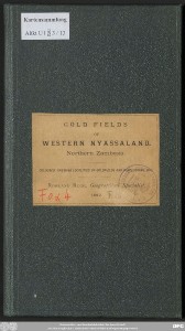
| dc.title | Ruggs new map of the western Nyassaland goldfields : specially illustrating the explorations of Carl Wiese : from 1885 to 1891, shewing his routes, trading stations and the localities of the old Portuguese gold fields of northern Zambesia ... including the Portuguese statistics of the Maravia gold exportations for the years 1810, 1830, and 1835 / by Rowland Rugg, geographical specialist to the late geographer to the Queen ; drawn & lith by R. Rugg | - |
| dc.title.alternative | Gold fields of western Nyassaland, northern Zambesia | - |
| dc.type | Map | - |
| dc.identifier.urn | urn:nbn:de:gbv:3:3-1192015415-1800375050-13 | - |
| dc.identifier.shelfmark | Altkt U I [3] 3/13 | - |
| local.openaccess | true | - |
| dc.identifier.ppn | 1800375050 | - |
| local.mets.uri | https://opendata.uni-halle.de/retrieve/93d4ed97-1e14-4c0f-99fc-707806b502a6/mets.xml | - |
| local.holding | Universitäts- und Landesbibliothek Sachsen-Anhalt | - |
| local.holding.displayform | Universitäts- und Landesbibliothek Sachsen-Anhalt, Altkt U I [3] 3/13 | - |
| dc.contributor.cartographer | Rugg, Rowland | - |
| dc.date.digitization | 2025 | - |
| dc.description.note | Mit Bergstrichen | - |
| dc.description.note | Karte | - |
| cbs.contenttype.code | cri | - |
| cbs.contenttype.text | kartografisches Bild | - |
| cbs.digitization.displayform | Halle (Saale) : Universitäts- und Landesbibliothek Sachsen-Anhalt, 2025 | - |
| cbs.publication.displayform | London : Forster Groom, 1892 | - |
| cbs.picatype | Aa | - |
| dc.title.uniform | New map of the western Nyassaland goldfields | - |
| local.map.scale | 1:1 000 000 | - |
| local.map.scale_sort | 1:1000000 | - |
| local.map.coordinates | E 030 00 00-E 034 40 00/S 012 00 00-S 017 00 00 | - |
| Appears in Collections: | Karten und Atlanten | |
Ressources:
 |
|