Please use this identifier to cite or link to this item:
http://dx.doi.org/10.25673/56519Full metadata record
| DC Field | Value | Language |
|---|---|---|
| dc.date.accessioned | 2022-01-18T05:12:45Z | - |
| dc.date.available | 2022-01-18T05:12:45Z | - |
| dc.date.issued | 1770 | - |
| dc.identifier.uri | https://opendata.uni-halle.de//handle/1981185920/58471 | - |
| dc.identifier.uri | http://dx.doi.org/10.25673/56519 | - |
| dc.description.sponsorship | Die Digitalisierung wurde durch die Deutsche Digitale Bibliothek im Rahmen des von der Beauftragten der Bundesregierung für Kultur und Medien (BKM) geförderten Programms NEUSTART KULTUR ermöglicht. | - |
| dc.format.extent | 1 Karte; 53 x 132 cm | - |
| dc.format.extent | Kupferstich | - |
| dc.language.iso | fre | - |
| dc.publisher | [Tobias Conrad Lotter] | - |
| dc.rights.uri | https://creativecommons.org/licenses/by/4.0/ | - |
| dc.subject.ddc | 090 | - |
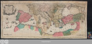
| dc.title | Carte Geographique representant la Mer Mediterranée ou la seconde Partie Du Théatre De La Guerre Entre Les Russes Et Les Turcs : C'est à dire Les Roiaumes, Les Etâts, Les Provinces Et Les Diverses Isles Situées Dans La Dite Mer, avec Mer Noire ou Pont Euxine et une Partie de la Province Georgie en Asia / Par Tobie Conrad Lotter, Geogr. à Augsbourg | - |
| dc.type | Map | - |
| dc.identifier.urn | urn:nbn:de:gbv:3:3-1192015415-1022346571-19 | - |
| dc.identifier.shelfmark | Altkt K III 2 [1] 7 | - |
| local.openaccess | true | - |
| dc.identifier.ppn | 1022346571 | - |
| local.comment.extern | Koloriert | - |
| local.mets.uri | https://opendata.uni-halle.de/retrieve/f8c77bd7-3086-4309-b43e-42049d1ea0d9/mets.xml | - |
| local.holding | Universitäts- und Landesbibliothek Sachsen-Anhalt | - |
| local.holding.displayform | Universitäts- und Landesbibliothek Sachsen-Anhalt, Altkt K III 2 [1] 7 | - |
| dc.contributor.cartographer | Lotter, Tobias Conrad | - |
| dc.date.digitization | 2022 | - |
| dc.description.note | NNE oben. - Maßstab in grafischer Form (Degrez, Lieües). - Nullmeridian: Ferro | - |
| dc.description.note | Titelkartusche oben links. - Maßstabsleisten unten links und rechts | - |
| dc.description.note | Windrosen, Bergzeichnung | - |
| dc.description.note | Auf 3 Blättern gedruckt | - |
| dc.description.note | Altkarte | - |
| cbs.contenttype.code | cri | - |
| cbs.contenttype.text | kartografisches Bild | - |
| cbs.digitization.displayform | Halle (Saale) : Universitäts- und Landesbibliothek Sachsen-Anhalt, 2022 | - |
| cbs.publication.displayform | [Augsburg] : [Tobias Conrad Lotter], 1770 | - |
| cbs.picatype | Aa | - |
| local.map.scale | Circa 1:4 300 000 | - |
| local.map.scale_sort | 1:4300000 | - |
| local.map.coordinates | W 019 00 00-E 044 30 00/N 051 05 00-N 025 00 00 | - |
| Appears in Collections: | Karten und Atlanten | |
Ressources:
 |
|