Please use this identifier to cite or link to this item:
http://dx.doi.org/10.25673/62489Full metadata record
| DC Field | Value | Language |
|---|---|---|
| dc.contributor.other | Hausermann, A. | - |
| dc.date.accessioned | 2022-02-03T07:50:24Z | - |
| dc.date.available | 2022-02-03T07:50:24Z | - |
| dc.date.issued | 1901 | - |
| dc.identifier.uri | https://opendata.uni-halle.de//handle/1981185920/64440 | - |
| dc.identifier.uri | http://dx.doi.org/10.25673/62489 | - |
| dc.description.sponsorship | Die Digitalisierung wurde durch die Deutsche Digitale Bibliothek im Rahmen des von der Beauftragten der Bundesregierung für Kultur und Medien (BKM) geförderten Programms NEUSTART KULTUR ermöglicht. | - |
| dc.format.extent | 1 Karte; 72 x 98 cm | - |
| dc.format.extent | farbig | - |
| dc.language.iso | fre | - |
| dc.publisher | Société d'Éditions Géographiques, Maritimes et Coloniales | - |
| dc.publisher | Imp. Dufrénoy | - |
| dc.rights.uri | https://creativecommons.org/licenses/by/4.0/ | - |
| dc.subject | Sahara | - |
| dc.subject.ddc | 090 | - |
| dc.subject.other | BK:74.23 | - |
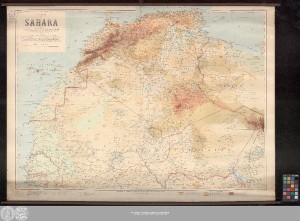
| dc.title | Carte du Sahara / dressée par le Capitaine G. Delingette de l'infanterie coloniale ; Lauréat de la Société de Géographie et de la Sté. de Géographie commerciale de Paris, de la Société de Topographie de France ; d'après les travaux des Officiers du Service géographique de l'Armée (Comts. Weil, Grall), de la Mission du Chemin de fer Transafricain (Col. Niéger) ... ; gravé par A. Hausermann | - |
| dc.type | Map | - |
| dc.identifier.urn | urn:nbn:de:gbv:3:3-1192015415-601296818-16 | - |
| dc.identifier.shelfmark | WK 1305 | - |
| local.openaccess | true | - |
| dc.identifier.ppn | 601296818 | - |
| local.comment.extern | Wandkarte auf Leinen gerollt, oben und unten mit Stäben | - |
| local.mets.uri | https://opendata.uni-halle.de/retrieve/4ecdc8e5-22c4-47cd-9458-a2b2afc1378a/mets.xml | - |
| local.holding | Universitäts- und Landesbibliothek Sachsen-Anhalt | - |
| local.holding.displayform | Universitäts- und Landesbibliothek Sachsen-Anhalt, WK 1305 | - |
| dc.contributor.cartographer | Delingette, G. | - |
| dc.contributor.publisher | Société d'Editions Géographiques, Maritimes et Coloniales | - |
| dc.contributor.publisher | Dufrénoy | - |
| dc.date.digitization | 2022 | - |
| dc.description.note | Mit Randüberzeichnung | - |
| dc.description.note | Karte | - |
| cbs.contenttype.code | cri | - |
| cbs.contenttype.text | kartografisches Bild | - |
| cbs.digitization.displayform | Halle (Saale) : Universitäts- und Landesbibliothek Sachsen-Anhalt, 2022 | - |
| cbs.publication.displayform | Paris / Paris : Société d'Éditions Géographiques, Maritimes et Coloniales ; Imp. Dufrénoy, [1. Hälfte 20. Jahrhundert] | - |
| cbs.picatype | Aa | - |
| local.map.scale | 1:4 000 000 | - |
| local.map.scale_sort | 1:4000000 | - |
| local.publication.edition | Édition provisoire | - |
| Appears in Collections: | Karten und Atlanten | |
Ressources:
 |
|